|
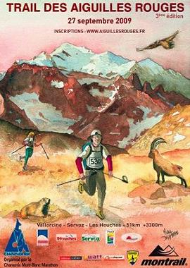
The
Trail des Aiguilles Rouges
Article
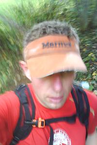
by Kingsley Jones, Icicle Chamonix head UIMLA guide

In terms of the length of the race, it is 51km,
so falls into the ultra-marathon category. Then
you add in the height gain of 3300m, and a height
loss of 3500m, and you start to get an idea of what
the race is really like. Less than a kilometer of
the race is on roads, and the rest is on single
tracks and for a good while over bare rock and scree
slopes. It may come as a surprise, but each edition
of this race is becoming filled with competitors
earlier each year, so for the 2009 race nearly 700
racers had signed up.
This mountain ultra-marathon had to be semi-autonomous,
due to the terrain and lack of access for supply
or rescue vehicles, so there were only a few drinks
and food supply stations along the route. All runners
had to carry compulsory safety gear including fluids,
snacks, waterproof jacket, head torch, survival
blanket, whistle, strapping tape, mobile phone,
and trekking poles. |
|
|
|
I'd done enough training through the summer, and my guiding
work had ensured that I was well acclimatised, but even
so it was the end of season and I was concerned about
the effects of cumulative fatigue, especially in my legs.
Still, enough of the excuses, I was looking forward to
this race as neither the distance or height gain was a
real concern, just the effects of combining both! On the
day before the race I travelled to les Houches to get
my race number and to have the kit checks and race briefing.
The briefing was important as the majority of the race
route was through national parks, where the key focus
of on preserving nature and not littering. Clearly some
people didn't heed the briefing too much as I saw several
energy gel wrappers dropped on the ground, which was a
shame, and totally against the whole ethos and ambitions
of the race organisers. |
|
 |
|
On
the morning of the race, I got up at 03:00am to quickly
get dressed and to walk across town to catch the free
bus to the start of the race at Vallorcine near the Swiss
border. While on my way to the bus, I saw other runners
leaving buildings on their way too, and soon a procession
of us walked across town. We passed some confused looking
people who were on their way home after a big night on
the town. It pretty much summed up what Chamonix is like;
a wierd mix of those passionate about their sport, and
those equally passionate about their beer. There's only
a few people I know who manage to live both lives simultaneously,
and the majority of them aren't especially good at either.
Still it was amusing to get cheered on by drunks, when
we hadn't even started yet.
The race bus was full
of some sleepy runners, and some hyperactive runners who
had clearly eaten their museli that morning. At Vallorcine
we were treated to a breakfast, then it was time to get
warmed up a bit and drop off the warm clothes and get
tagged on the way to the start line. The start was scheduled
for 05:00am, so it was still pitch black and all runners
had a head torch on to see where they were going. There
was the usual dubious choice of music blaring through
the speakers, and a MC who hadn't got a job on a radio
station to 'get us going'. It was a relief when we started
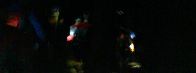
and left it all behind. Off into the dark we went, and
soon left the village behind and headed into the woods
and onto the trails. The photo above shows the visibility
- pretty much nothing apart from a pool of light in front
of you. I'd never done any night racing before, so this
experience was quite exciting. It started raining a little
bit, which was fine as it kept me cool, but it made the
rocks and grass very slippery. |
|
 |
|
We
threaded our way through Barberine on the Swiss
border, then back to Vallorcine, where we crossed
a road for the last time until a few kilometers
from the end of the race. Then it was a steep uphill
section through the forests to the tiny hamlet of
Les Granges. I can't count the number of times I
have walked, snowshoed, or skied through the chalets
there, but in the dark it was slightly unfamiliar
and ghostly. Then back into thick forests on the
traverse past the Val de Tré Les Eaux to
the Berard valley. As I climbed upwards the race
pack was spreading out a little, and I managed to
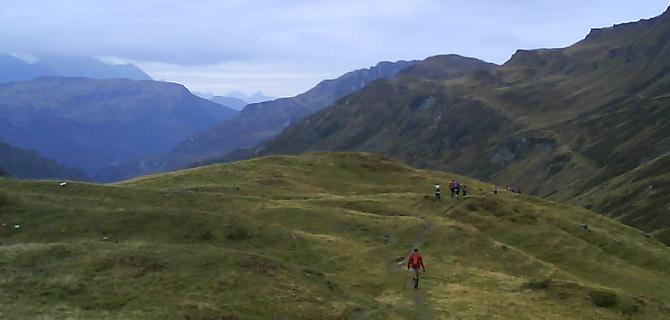
get my pace a bit better. Eventually I climbed above
the treeline, and entered the upper Berard valley.
I could pretty much walk this upper valley blindfold,
but when running you look at the familiar through
different eyes, and whilst I recognised it all,
it seemed to pass in a blur. No I wasn't running
that fast, but I was going quicker than I had expected.
Soon I crossed the final bridge over the stream
and made my way up the steep zig-zags towards the
hut. As I neared the hut I saw the guardians on
the terrace and when they spotted me they run the
cow bells they held, and cheered me on. This was
a great boost, and welcome support. |
|
|
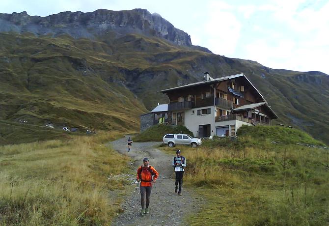
At
the Pierre à Bérard refuge, it was
the first drinks station, and another key feature
of this trail race was that each runner had to carry
their own cups for drinks to avoid the huge wastage
that you see at road races. This was a great idea,
and didn't hold the runners up at all really. Hopefully
this is the way of things to come, and will be adopted
at other races. After a quick drink I took off my
headtorch as it was light enough to see now, and
headed up the steep hillside behind the hut, towards
the high point of the race at the watershed of the
Col du Salenton, at 2526m.
This section of the
race was always going to be very tough on the legs,
as it is brutally uphill, gaining over 600m in about
1km. The first part is up steep rocky tracks, which
were quite slippery with mud, then the paths gave
way to bare rock. This is where I was more confident
that my climbing background would help power me
through. Marker flags showed the way up through
the rocks, and I overtook several people. A few
runners went off route, which I knew from guiding
work, would loose them time. Then the fog came in,
with a little bit of sleet mixed in from time to
time. The temperature was around freezing. |
|
 |
|
|
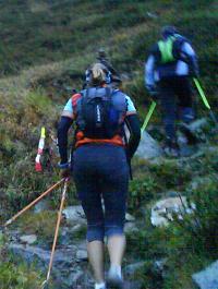
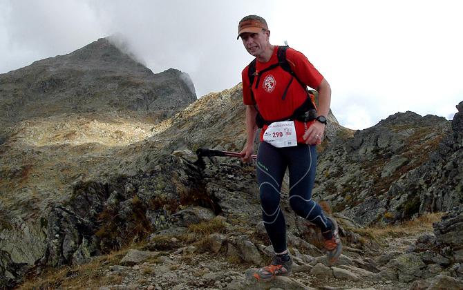
| It
was raining lightly, and the fog became denser and denser.
The photo above shows me making the final steps across
the traverse to Col du Salenton, which was only visible
from less than 10m away through the fog. There was a medic
there to assist runners with problems. I stopped for a
second at the col to put on a jacket, as the next section
was a long descent past the Chalets de Villy. The first
part from the col was steep loose rock. Screes of slates,
shales and limestone, which were tricky to run on, as
with each step my feet sank in to deep wet muddy scree.
Finally the screes gave way to nice spongy grass on the
alpages above the valley floor. |
|
 |
|
My
next objective was the Moede Anterne refuge, which at
a regular walking pace would be 2 hours away. It was quite
hard to look after the ankles and legs on the descent,
whilst still pushing on the pace. I could feel my legs
suffering a bit after the ascent to Salenton, and it was
good to get supported as I ran through the small collection
of farm buildings at the Chalets de Villy. After the farm
was a nice flat track, which then turned the corner past
the ruined buidings, then headed upwards up the long rock
ramp to award the first views of the Moede Anterne refuge.
After the corner the track rises and falls, crossing several
streams, before the final approach to the hut. Here was
a food and drinks station, and I made a point of eating
to replenish my energy levels, as I was nearly half way.
In
terms of timings, I had built up a good margin above the
cut offs, of over an hour and a quarter. This was great
news so early in the race, but I had a feeling that I'd
be calling on that margin in the closing stages. I set
off from the hut towards the Pont de Arlevé, which
marked the half way point in the race, and also the start
of the largest single height gain, the huge ascent up
to Brevent. The descent to the bridge was muddy, and I
wanted to try and keep my feet dry to avoid blisters.
Just before the bridge I swallowed an energy gel, to provide
a boost on the climb. At the half way point a runner limped
up the hill towards me, having clearly twisted his ankle
and abandoning. As the climb started I past the half way
at just over 5 hours, so one and a half hours ahead of
the cut off margin now. |
|
 |
|
| Directly
above the bridge the track zig-zags steeply upwards through
rhododendron bushes with big drop off back down to the
river gorge. I set my pace and tried to keep a good pace
on the way up the hill. In my head I had set the ruins
of the Chalets d'Arlevé as the next objective to
focus on, as this was a good 300m above the bridge. After
I reached the ruins, I knew the path flattened out for
a while, which was good to slightly rest the legs a bit. |
|
It
had planned to eat another energy gel at this point,
but perhaps mistakenly I felt fine so carried on
until I could see the steep zig-zags above me stretching
on up to the Col du Brevent. Suddenly the legs were
feeling it more, and so I grabbed an energy gel.
It tasted disgusting, but did the trick, and soon
I got my rhythm back and was powering upwards again.
The ascent was long and it was quite hard to keep
up the pace, but I knew that the col was approaching.
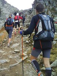
Here in the photo on the right is the final approach
to the Col du Brevent.
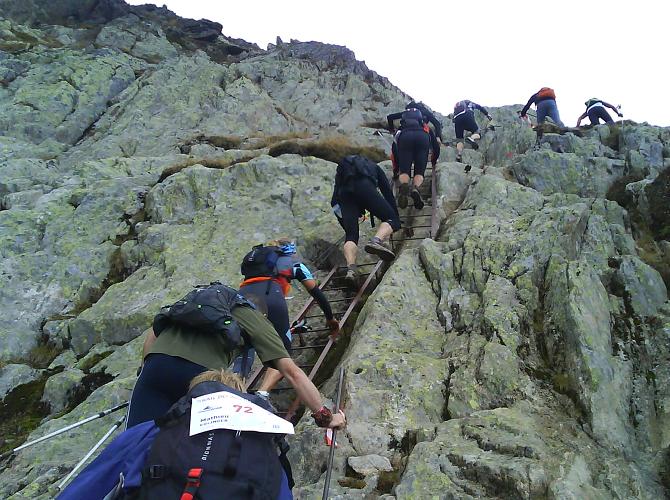
Here there is a traverse across to Le Brevent itself,
and it goes on for quite a while. At the end of
the traverse the track was crossing quite steep
ground on solid rock, and at the far end of the
traverse was a series of ladders leading up to the
cliffs. This caused a bit of a bottleneck, as you
can see from the photo below, but after the ladders
the runners spread out more on the final haul up
to Brevent. There were a fair few well wishers who
had hiked up to Brevent from Chamonix, and they
cheered everyone onwards. The ground underfoot was
very broken rock. Finally I rounded the final corner,
and the Brevent was right in front of me. I got
my race number tagged and went to the drinks station. |
|
|
|
|
 |
|
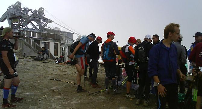
I
stopped at the Brevent for a couple of minutes, as I had
built up my margin ahead of the cut offs to just over
two hours. Also a couple of my toes were rubbing, so I
taped them up. The mists had descended again, as you can
see from the photo below, the amazing views you usually
get across to Mont Blanc were sadly missing. The quick
break was much welcomed, but it was time to go again,
and I knew the next part of the race was potentially where
I was going to lose the most time, due to the steep descent
towards Servoz. I got going again, and headed down towards
the Aiguillette des Houches. The legs were definately
feeling it at this stage, but I had to press on.
The
first part of the descent is towards the Bel Lachat refuge,
which is perched on the ridgeline far above the Chamonix
valley. The track is good, but it is rock steps, and so
quite tough on the knees. My legs weren't too keen on
running at this stage, but I pressed on and passed a couple
of the flashpoint photographer points. I remember feeling
quite sorry for the paps as the Brevent cable car was
closed, and so they had all hiked up from the valley to
take their shots for the runners, so a good effort from
them! Soon I past the Bel Lachat after the section with
handrails, then run across my favourite section of the
course, the lakes of the Aiguillette des Houches. |
|
 |
|
I
had often walked my dog on this section during the summer
months, so knew every twist and turn, but by this stage
I was approaching a full marathon distance, and so the
footwork wasn't too good, and I wasn't gaining time any
more. As the waypoint of the Aiguillette des Houches approached,
I knew that I had run the last sector in exactly the minimum
required time. No I hadn't eaten into my two hour time
margin, but it still was a shock to see that I had gone
from gaining a margin to maintaining a margin, and the
realisation spurred me on to push towards the small summit
ahead. On the way I ran past several hikers, who had chosen
to walk the same route as this part of the race. They
looked a bit depressed to be overtaken by yet more runners,
but cheered us on.
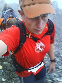
On
this section I was running with someone with a Basque
flag wrapped around their head, who was suffering too.
This didn't help much, but it was good to see I wasn't
the only one. Below is a photo of me on the way to Aiguillette
des Houches, and you can see from the look on my face
that it wasn't a feel good moment! Anyway the top was
reached and then ahead lay the 1500m descent to Servoz.
This was the section we had been warned about in the race
briefing, but fortunately it was dry on the upper section,
and so the mammoth descent began! |
|
 |
|
As
I ran across the top narrow ridge I passed a group cheering
runners on by ringing cow bells, then as I rounded the
corner I saw the ridge dropping away in front of me. I
slowed down as it was loose underfoot, and several runners
overtook me, but I was concentrating on the ground under
my feet, so happily let them by. I looked at my altimeter
and saw that the rate of descent was about 20 to 25m per
minute, that meant 5 minutes per 100m, so 50 minutes per
thousand so about 1 hour 20 for the total descent. That
was a bit slower than I'd been hoping for, but I was keen
to finish without a twisted ankle. It took what seemed
like ages to reach the treeline, then again ages to reach
the 1500m contour. My mind was working against me, as
I compared big mountain descents to sections of this route,
so knew that from 1500m to Servoz was still the same as
descending Mont Blanc du Tacul to the Col du Midi.
It
also didn't help that as I descended that the ground turned
from rock and dry track to wet and muddy grass. I slipped
around a fair bit, and just ahead of me one runner took
about a 10m fall, before bouncing up onto his feet and
carrying on. After what seemed like an age, I finally
reached the upper chalets in the forests above Servoz,
and the ground dried up a little but was now covered with
a good coating of autumn leaves. |
|
 |
|
At
the halmet of Montvaultier the route twisted around
a fair bit, and then it dropped steeply onto the
track leading into Servoz. The photo on the left
is on one of the last sections of the forest track.
About 100m above the village I got onto the road. Here there were lots of people
cheering the runners on which was a good boost to
the morale. I turned into the village, and crossed
the main road to enter the old village centre. Here
was the final drinks and food station of the race.
By this stage I had already run over a marathon
distance, and so the energy levels were running
a bit low. Several other runners sat at the drinks
station, totally spent and some pulling out.
Across the road from the drinks station is a small
bar, where the locals were sitting outside, to watch
the runners. On the speakers I remember they were
playing Hallelujah sung by Jeff Buckley. It was
far too relaxed a mood, and far too soft and emotional
a song to hang around. Everything was telling me
to stop, but I knew I had to keep pushing onwards
or I would stop. On the descent I had lost nearly
half an hour from my margin, which was not a surprise,
but it still gave me a good hour and a half margin
before the cut off time. My legs felt like lead,
but I soon got running again and headed off from
the drinks station. The weather was good now, and
some sun was shining through. |
|
|
As
I approached the Servoz bridge, I saw my wife Sarah ahead
with our dog Max. It was brilliant to see them, but equally
quite hard. I wanted to stop, and seeing them didn't help
those feelings, but it did spur me on to finish as they
had come to support me. As the track turned off from the
road, they ran with me for a couple of hundred metres,
then promised to see me at the end. As I left them behind
I had no doubt that I would reach the finish, but I had
no idea how much I would eat into my time margin. I crossed
the bridge at Chatelard and headed upwards again. The
uphill was agonising, as there was nothing left in my
legs. The track headed straight up a very steep hill through
the trees, and I remember looking upwards to a runner
about 100m above me, but it felt like they were a mountain
above me. Finally the ground flattened off a little, but
it was a false top and the route continued upwards. I
reached some ruins, which I knew meant that the route
then traversed towards Vaudagne. My legs weren't capable
of much, but I tottered along the traverse, and got to
the roads of the village.
Here I reached a real
low in the energy levels, but all the locals I passed
cheered me on, pointing out the way on. Clearly I wasn't
looking too good. I stopped for a drink at a water trough,
then climbed up and out of the village on a steep track.
The energy wasn't getting any better, and I felt like
I wanted to stop again. Runners overtook me, and on a
signpost I saw it was marked as nearly two hours to Les
Houches centre, so didn't feel much better for it. By
this stage I was running with a guy from Luxembourg, and
we passed through the alpage or Charousse. I knew that
Les Houches and the finish was just ahead, perhaps only
2km away. I could vaguely hear the speakers of the finish
announcers, and I picked up the pace a little. As I reached
the edge of the village people were lining the roads,
and offering encouragements saying that the end was only
about 10 minutes to go. The route then took a little track
to cut a few corners of the road, and then suddenly I
emerged onto the road again. A policeman was ahead holding
up the traffic, and I knew that I was a few hundred metres
from the finish. I picked up the pace again, and ran across
the road and made the final turn towards the lake. Hundreds
of people were gathered there to see the racers home and
I ran around the edge of the lake totally forgetting the
pain I had been in for the last couple of hours. |
|
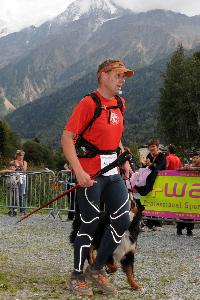
Ahead
I could see the finish line and arch, and as I approached
the line I saw Sarah and Max waiting for me. As
I ran past them I grabbed the dog lead, so I could
run over the line with Max, as you can see from
the photo on the right. As I crossed the line, I
could hear the commentator shout out my name, and
knew it was all over. I got my race number tagged
and my finish time was 11 hours 25 minutes. The
winners had crossed the line five hours before me,
but I was happy. I recovered my clothes bag, and
then walked back to the car that Sarah had driven
to collect me. It was all over, but I felt no endorphin
high. I felt empty and finished, yet remarkably
proud. I knew good runners who had failed to finish
this race, and I loved the region I had run through.
It had been a very different experience to race
through familiar terrain.
As
Sarah politely noted a couple of days later, "you've
got to be a bit wierd to run for eleven and a half
hours", but it wasn't the time or the physical
effort required that I remember at all for this
race. It was the mental games that your mind plays
with you over that timescale, and the games you
play with it, that create a unique experience. Sometimes
you are at the top of the world, and at other times,
you explore the lows. The emotional journey is tougher
than the race itself, but it makes this race exceptionally
hard. |
|
|
|
|
I
remember telling people afterwards that I wouldn't ever
do this race again, and I definately hurt my feet a bit,
but a few days later felt great again, and went walking
and running in the hills above Lake Maggiore in north
Italy. The memories of the pain had faded to be replaced
by a real sense of satisfaction, and a perverse feeling
of having won over my brain telling me to stop. It was
the hardest race I've ever done, and perhaps because it
was so tough at the time the 'high' wasn't immediate,
but spread out over time as you glance up at sections
of the route, and remember running along it. The Trail
des Aiguilles Rouges was an amazing and remarkably personal
experience, and one that I would now love to do again.
It's just too soon and too raw in my mind to even consider
signing up for yet.
| | | |